
File:Banyak Islands.jpg

Size of this preview: 559 × 600 pixels. Other resolutions: 224 × 240 pixels | 447 × 480 pixels | 716 × 768 pixels | 954 × 1,024 pixels | 1,493 × 1,602 pixels.
Original file (1,493 × 1,602 pixels, file size: 286 KB, MIME type: image/jpeg)
Captions
Captions
Add a one-line explanation of what this file represents
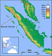
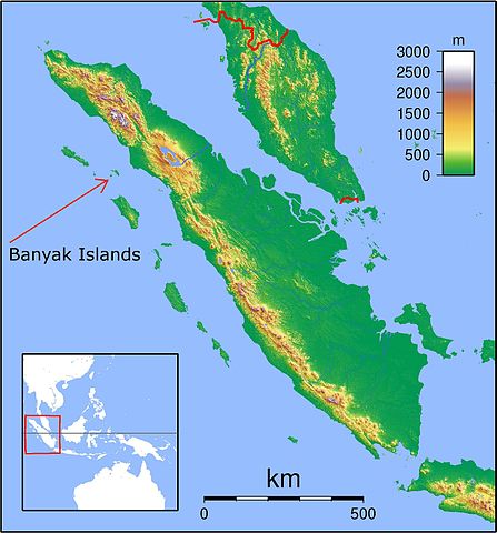
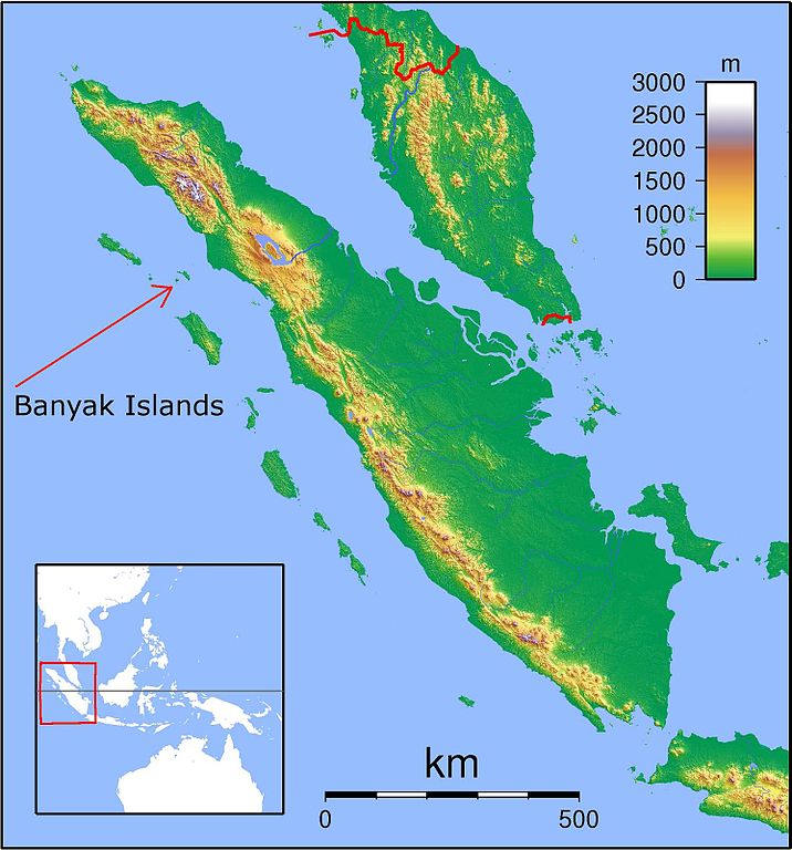
| Description | Topographic locator map of Sumatra. Created with GMT from SRTM data. For non-locator version, see Image:Sumatra Topography.png. Left:94 Bottom:-8 Rght:108 Top:7 |
| Date | (UTC) |
| Source | |
| Author |
Historymike (talk) 20:29, 16 December 2009 (UTC)
|
| This is a retouched picture, which means that it has been digitally altered from its original version. Modifications: Added identifying text and arrow to Banyak Islands for Banyak Islands Wikipedia page.. The original can be viewed here: Sumatra Locator Topography.png:
|
I, the copyright holder of this work, hereby publish it under the following licenses:
This file is licensed under the Creative Commons Attribution-Share Alike 3.0 Unported, 2.5 Generic, 2.0 Generic and 1.0 Generic license.
- You are free:
- to share – to copy, distribute and transmit the work
- to remix – to adapt the work
- Under the following conditions:
- attribution – You must give appropriate credit, provide a link to the license, and indicate if changes were made. You may do so in any reasonable manner, but not in any way that suggests the licensor endorses you or your use.
- share alike – If you remix, transform, or build upon the material, you must distribute your contributions under the same or compatible license as the original.

|
Permission is granted to copy, distribute and/or modify this document under the terms of the GNU Free Documentation License, Version 1.2 or any later version published by the Free Software Foundation; with no Invariant Sections, no Front-Cover Texts, and no Back-Cover Texts. A copy of the license is included in the section entitled GNU Free Documentation License. |
You may select the license of your choice.
Original upload log
[edit]
This image is a derivative work of the following images:
- File:Sumatra_Locator_Topography.png licensed with Cc-by-sa-3.0,2.5,2.0,1.0, GFDL
- 2007-09-01T18:56:23Z Sadalmelik 1866x2002 (2373775 Bytes) {{Information |Description=Topographic locator map of Sumatra. Created with GMT from SRTM data. For non-locator version, see [[:Image:Sumatra Topography.png]]. Left:94 Bottom:-8 Rght:108 Top:7 |Source=self-made |Date=Sep 1, 2
Uploaded with derivativeFX
File history
Click on a date/time to view the file as it appeared at that time.
| Date/Time | Thumbnail | Dimensions | User | Comment | |
|---|---|---|---|---|---|
| current | 20:29, 16 December 2009 | | 1,493 × 1,602 (286 KB) | Historymike (talk | contribs) | {{Information |Description=Topographic locator map of Sumatra. Created with GMT from SRTM data. For non-locator version, see Image:Sumatra Topography.png. Left:94 Bottom:-8 Rght:108 Top:7 |Source=*File:Sumatra_Locator_Topography.png |Date=2009- |
You cannot overwrite this file.
File usage on Commons
The following page uses this file:
File usage on other wikis
The following other wikis use this file:
- Usage on ar.wikipedia.org
- Usage on az.wikipedia.org
- Usage on ban.wikipedia.org
- Usage on ca.wikipedia.org
- Usage on en.wikipedia.org
- Usage on es.wikipedia.org
- Usage on fr.wikipedia.org
- Usage on id.wikipedia.org
- Usage on ml.wikipedia.org
- Usage on ms.wikipedia.org
- Usage on nl.wikipedia.org
- Usage on pl.wikipedia.org
- Usage on pt.wikipedia.org
- Usage on ru.wikipedia.org
- Usage on www.wikidata.org
- Usage on zh.wikipedia.org